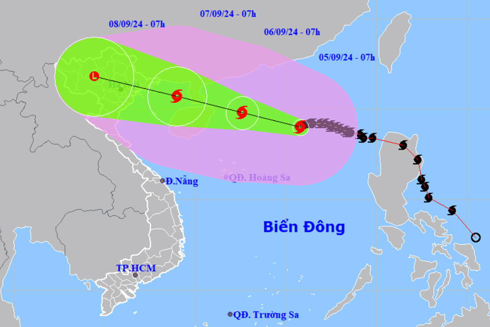
By the afternoon of September 6, the storm will reach wind speeds of Level 15 – 16, near the eastern area of Hainan Island, China, before weakening as it moves into the Gulf of Tonkin.
The northern localities of Quang Ninh, Hai Phong, Thai Binh, Nam Dinh, and Ninh Binh are predicted to be most heavily impacted by Typhoon Yagi, the third to enter the East Sea this year and considered the strongest hitting the Gulf of Tonkin in a decade, Deputy Director of the National Centre for Hydro-Meteorological Forecasting Hoang Phuc Lam has said.
At a press briefing on the storm’s status on September 4, Lam noted by the afternoon of September 6, the storm will reach wind speeds of Level 15 – 16, near the eastern area of Hainan Island, China, before weakening as it moves into the Gulf of Tonkin. There is high likelihood, around 70-80%, that it will enter the gulf.
It has now strengthened to Level 12 – 13, four – five levels higher compared to initial information.
He noted that while the hot and humid weather in the northern and north central regions is not conducive to storm development, it does increase the risk of tornadoes before its arrival. It is forecasted that by the afternoon of September 6, when Yagi is 400-500km away from the mainland, the northern region, including Hanoi, will experience thunderstorms with lightning, particularly in northeastern areas.
Regarding the typhoon’s progress, Lam indicated that around September 6 night or early September 7, it will enter the north of the Gulf of Tonkin with wind speeds of Level 12 – 13, gusting up to Level 15. Coastal areas in the northern and north-central regions will face strong winds of Level 10 – 11, with gusts of up to Level 12. Heavy to very heavy rain is expected from September 7 – 9 across the regions, raising the risk of flooding, flash floods, and landslides.
From now until the end of 2024, storms are expected to peak in October. Those in September will mainly affect northern provinces while from October to November, they are likely to concentrate on the central region, especially its central part, he noted.
Dinh Huu Duong, head of forecasting at the hydro-meteorological station for northern delta and midland areas, said due to the impact of Yagi, sea waves off the coast from Quang Ninh to Ha Tinh provinces will be high, posing a danger to ships, including those anchored in ports but not comprehensively taking safety measures.
Hanoi is expected to start feeling the impact of this storm on September 7, with heavy rainfall over a short period potentially overwhelming the city’s drainage systems, causing flooding in low-lying areas./.
Source: Vietnamnet


